When selecting a runway for takeoffs and landings, head wind is always preferable to a tail wind when the wind strength is of some significance. This is a general aviation rule which I don’t think can be disputed. I have noticed that many times VATSIM assigns runways with less than optimal wind conditions. Here is an example.
In a flight KMSP to KEWR, Simbrief assigned destination runway KEWR/4R. Looking at the wind conditions prior to takeoff, this runway was appropriate. However, after takeoff I checked the destination wind conditions again and the winds shifted so now runways KEWR/22R and 22L had the head winds. During the 2+ hours of air time the winds got stronger and they also started gusting at 18 KTS. Navigraph’s “Runway” function as well as NOAA indicated head winds for runways 22R & 22L for the duration of the trip so my expectation was VATSIM would assign one of these two runways. To my surprise, I was assigned runway 4R, which had a significant tail wind component, so when I landed I barely avoided overshooting the runway…looong, 10,000’ runway ! This was not a case where the winds shifted suddenly. The window of opportunity to switch runways was 1-2 hours long.
The above example is not unique. I have observed less than optimal runway assignments many times in the past. Please let me know if there is anything I am missing. Is it appropriate for me to request a runway based on my observations of wind conditions instead of relying on VATSIM ? Any advice on this matter is appreciated.
This does seem odd for you on this one to take a headwind for a departure, but there are a couple of factors that will come into play with what you experienced here.
First, the weather used on VATSIM may not be what Simbrief is reporting and vice versa. If possible, it would be best to use the weather that is reported on the network, as the controllers will have winds different than an external dispatch network like Simbrief may provide. That would be one of the biggest factors here.
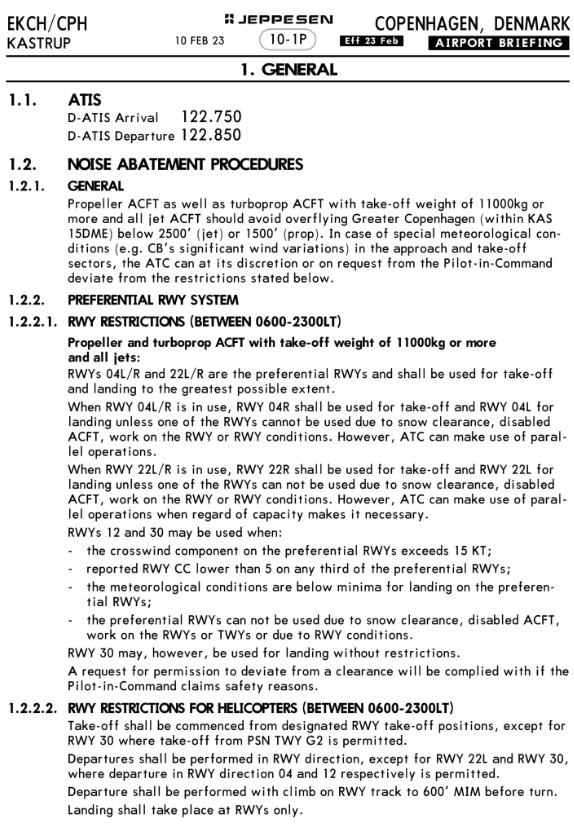
Second, what Simbrief may offer may be against SOPs for a given airport. For example, if you were given winds 01015G29 going into KLAS, Simbrief may tell you that 1L/R may be what you’re should get, but you could get 26L, giving you a significant crosswind, because SOPs that we have state that 26L would be the offloading runway should the arrival stream into the 1s get too full.
Another example: you get a 25009 wind going into LAX, where Simbrief tells you you should get 24R or 25L for arrival. But you’re arriving after midnight, where noise abatement procedures go into effect, and in actuality, you get 6R for arrivals. Simbrief wouldn’t allot for that, because they don’t know about SOPs at a given airport.
So a pilot also has to take into account SOPs and current runway configs at an airport prior to planning and filing a flight plan. Here is where the ATIS would come in to help, so finding out that info prior to planning can help to alleviate some of the problems you are experiencing. That isn’t to say that something isn’t wrong with what the controller gave you, but that these are options that can be taken on both sides to eliminate the problem from occurring entirely.
Thank you for the response. The SOPs and general restrictions that could be in effect is something I am aware of but I don’t think this was the case today. I also don’t think there was an issue with landing streams being full. Per the ATC communications, traffic inbound to KEWR was light. I don’t remember any aircraft ahead of me or behind me during initial and final approach. However, you points on SOPs and other restrictions are well taken and will focus on them more in the future. I do have a few follow-up questions.
Planning a Flight
For every flight, I always review the destination airport layout and runway options. This is how I knew Simbrief’s recommendation of runway KEWR/4R was fine at the beginning of the flight but became inadequate when the winds changed sometime in the early part of the flight. The problem though seems to be the weather source (I used Simbrief). You’re suggesting ATIS would help but how do I receive ATIS for KEWR when I am at the gate at KMSP ? When I was in range, I did listen to ATIS and the information matched the final runway assignment by the controller.
Weather Information Synchronization
There seems to be a weather synchronization conundrum here. We have:
Weather in MSFS 2020…which is what really counts.
Weather reported by Simbrief.
Note: In the no longer supported product TOPCAT, there are multiple options for obtaining weather one of which is NOAA. The weather information from here matches Simbrief every time, all the time.
Weather ATC sees.
Is it possible to synchronize the above ? If there is, I don’t know how to do it so any help would be appreciated.
I deleted my post above because I mis-read your original post and realized you were assigned a runway at EWR by ATC, not taking your runway from Simbrief. My apologies for that.
Do you recall what the wind reading was on the ATIS for EWR as you approached the airport? If the reported wind was favoring the 22s but you were still assigned 4R, that would have been a good time to query the controller. If the ATIS, which is based on real-world METAR data that is typically only updated once per hour (unless the weather is changing rapidly), was incorrectly reporting winds favoring the 4s, but your simulator was receiving more updated weather, then that would indeed be a bigger issue.
Unfortunately I don’t remember what ATIS was reporting. However, you are touching on an interesting point. It is my understanding that weather data reported in Navigraph is real-world METAR data so if ATIS does the same, then in my situation today it sounds like the runway assignment wasn’t the best. Also, even though I did not mention it before, AI aircraft were departing one runway over to my left from runway 22R so this is another indicator that just looking at the weather factor, being assigned to 22L or 22R would have been the proper assignment. Anyway, if you or anyone else has any advice on this issue, I will take it…thanks.
Weather in MSFS2020 is not what really counts! When flying on a social network like VATSIM the VATSIM weather is what counts. Not everyone uses MSFS, so in order to have some common ground, you’ll need to use what the rest of the network can use - which is VATSIM weather. I don’t know much about MSFS but usually one can choose the VATSIM weather from the provider (ActiveSky for example).
When I said weather in MSFS2020 is what really counts, the point was that it’s the simulator’s weather that counts. I know there are other simulators so I was not in any way promoting MSFS2020. If you know how to have MSFS2020 use VATSIM weather, please let me know. When I was running FSX, ActiveSkyNext was my weather engine but now things have changed.
Under normal (network) conditions the METAR data at VATSIM is the same as what you will find on the NOAA feed. There may be a delay of up to 30 minutes from NOAA to VATSIM, but in your case the winds had been consistently favouring the 22s and not the 04s.
But: you are the PIC, you alone know the tailwind limits of your aircraft, you need to query ATC and request a different runway, if needed. Or divert.
Up to 10kts of tailwind component should be fine on a long runway, but you better make the calculation before accepting it.
When was your flight? You can lookup “Historic METAR data” (search for “Ogimet”) and see what the reported winds actually were!
Andreas,
Thanks a lot for your valuable feedback. I had no idea that METAR can be queried so I did and the results are below. I landed at 20:56z (I maintain a flight log, which includes flight times and fuel consumption for post-flight performance assessments) so you can see the problem I had landing was real, especially with a very slippery aircraft like the B738. Your points on the PIC’s responsibilities and authorities are well taken, and will take into consideration on future flights.
I am glad to see that METAR data is the same as the NOAA feed subject to network conditions. Earlier in this post, my dependence on Simbrief for destination weather might have been interpreted as me depending on the product to make the destination runway selection. Not the case ! I select the runway based on the METAR that is being reported in Simbrief/Navigraph for the destination and I change it frequently. I am confident in the correctness of this METAR (“correctness” means it’s what I see in the simulator). My confidence is based on the fact that the “AVG WIND” in Simbrief’s Briefing section has been matching what I see in flight for as long as I can remember. The direction and strength of the wind might vary a bit during flight but the general direction of the wind is always as expected, e.g., if “AVG WIND” along with “AVG W/C” suggest tail winds, tail winds I see in the simulator. This being the case, I don’t see why the destination METAR in Simbrief/Navigraph would be incorrect. I see the NOAA wind reports in TOPCAT (outdated product but still works well for runway wind conditions, using it until PMDG releases the EFB) and this matches what I see in Simbrief/Navigraph. Since METAR data at VATSIM is the same as the NOAA feed, there is no reason not to expect consistency across all three with some timing differences…NOAA METAR = Simbrief/Navigraph METAR = VATSIM METAR.
Also checking the previous METARs, you can see that the winds were not that strong or gusty, hence the ATCO was not using 22s. And if he did not have the latest METARs with those strong winds from the West, I understand why this has happened. He was trying to stick to their preferential runway system.
What you could have done is shoot the approach and see what the winds are like and if out of limits, go around and request a different runway.